Mylpg.eu
myLPG.eu - Save money save Earth
Find LPG (autogas) stations, installers, and fuel prices across Europe. Plan routes, compare savings, and learn about switching your car to LPG fuel.
Find LPG stations and plan routes across Europe
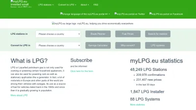
myLPG.eu is your go-to resource for finding LPG (autogas) stations and installers throughout Europe. Whether you're already driving an LPG-powered car or thinking about switching, you can easily search for stations, check up-to-date fuel prices, and plan your routes to make sure you never run out of fuel.
The site also offers handy tools like a savings calculator to see how much you could save by converting to LPG, plus lots of useful information about the benefits and process of using LPG as a vehicle fuel. If you're new to autogas or just want to explore your options, you'll find guides, articles, and even a mobile app to help you on the go.
myLPG.eu is great for environmentally conscious drivers and anyone looking to cut fuel costs while traveling across Europe. With its easy-to-use features and wide coverage, you'll have everything you need to make the most of LPG for your car.
 Alternatives to Mylpg.eu
Discover websites similar to Mylpg.eu based on shared categories, topics, and features.
Alternatives with .eu Domain Extension
overpass turbo lets you run custom map data queries on OpenStreetMap and visualize results directly in your browser. No software install needed.
Top Mylpg.eu Alternatives (Matching Language)
Track outbreaks of infectious diseases worldwide with interactive maps and real-time data on flu, Ebola, and other health risks in your area.
NNG offers navigation, guidance, and location-based data solutions to help you solve mobility challenges, with services for automotive and smart mobility.
Find and plan electric car charging stops across Europe with Chargemap. Access a community-driven map and use one pass for multiple charging networks.
Explore live global maps of wind, weather, ocean, and pollution conditions with interactive animations and real-time data, updated every three hours.
Find the latest news, reviews, and guides on electric and hybrid cars, fuel economy, and clean mobility. Stay updated on green vehicle trends and technology.
Explore the U.S. National Hydrography Dataset for detailed maps and data on rivers, lakes, and water networks across the country. Data in English.
Explore an interactive world map showing light pollution, aurora predictions, observatories, and cloud overlays for stargazing and astronomy planning.
Browse daily, global satellite images with NASA Worldview to track weather, wildfires, air quality, and natural events in near real-time.
Get the latest news, insights, and interviews about electric vehicles, green mobility, and the future of transportation, all in one place since 1998.
Track wildfire smoke and air quality across the US with an interactive map showing PM2.5 pollution to help you prepare and stay safe during wildfire season.
Explore interactive geospatial maps and data for environmental analysis and insights with Earth Engine Apps. Visualize changes and trends easily online.
Find EPA gas mileage, emissions, and safety info for cars and trucks. Compare vehicles, explore fuel-saving tips, and discover eco-friendly options.
Get German car news, photos, traffic updates, car guides, and fun features like auto jokes and tuning girls on this all-in-one automotive portal.
Trinity Metro helps you plan and ride public transit in Fort Worth, offering routes, schedules, ticket info, and real-time updates for local travel.
Track flights live on an interactive map and see real-time air traffic from around the world with Flightradar24's easy-to-use flight tracker.
Get schedules, real-time departures, trip planning, and service alerts for Bay Area Rapid Transit (BART) across the San Francisco Bay Area.
Plan your Metro trips, buy SmarTrip cards, view service alerts, and access maps and schedules for Washington, DC's Metrorail and Metrobus system.
Get real-time bus routes, schedules, and service updates for Madrid’s public transportation system. Plan your trips and stay informed easily.
ATM Milano helps you plan your journeys on Milan's public transit, offering routes, schedules, and info for buses, trams, and metro in Italian and English.
PostBus offers schedules, routes, and info for Swiss public bus transport, including updates on electric buses and travel options across the country.
More Mylpg.eu Alternatives
Find electric vehicle charging stations worldwide with this global, community-driven map and database, updated by EV drivers everywhere.
Navmii lets you add maps, search, and navigation to your apps with easy-to-use SDKs and APIs for mobile, web, and connected vehicle solutions.
Explore global surface water changes over time with interactive maps and data. Track environmental trends and access downloadable geospatial datasets.
Hrvatski autoklub (HAK) is Croatia's national club for drivers, offering road assistance, traffic updates, membership benefits, and travel info in Croatian.
Discover and connect with permaculture projects worldwide using an interactive map and database designed for the global permaculture community.
Easily customize the look of Google Maps for your apps or websites with this tool. Adjust colors, roads, and labels to match your unique style.
Plan your journey, check bus and tram routes, and buy tickets for public transport in Flanders, Belgium. Site available in Dutch.
Plan bus journeys, check timetables, and buy tickets for UK bus routes. First Bus helps you travel easily across cities and towns in England, Scotland, and Wales.
Get bus schedules, ticket info, and route updates from Israel's largest public transport company. Plan your trip, find discounts, and contact support easily.
Find useful plugins, controls, and resources to enhance your Leaflet maps. Explore extras that make interactive mapping easier and more powerful.
GPSLogger for Android lets you record and manage your GPS tracks on your phone, view different map presentations, and export location data easily.
Download computer-generated mountain panoramas and horizon maps for hiking and climbing across the British Isles, including custom viewpoints.
Bekijk actuele treinstoringen, vertrektijden en plan je treinreis binnen Nederland of naar België, Duitsland en Frankrijk. Site in het Nederlands.
Find transit routes, schedules, fares, and service updates for The Wave Transit System in Alabama. Plan your trip and stay informed about local transportation.
Plus Codes offers a simple way to share precise locations anywhere in the world, making it easy to find and navigate places without traditional addresses.
Explore and compare the true sizes of countries by dragging them on an interactive world map. A fun, educational tool for visualizing geography.
Explore details for over 83,000 airports worldwide, view maps, and access data—ideal for pilots, travelers, and aviation enthusiasts.
Explore metro, subway, and light rail systems from cities worldwide with detailed maps, photos, and facts for urban rail enthusiasts and travelers.
Plan trips, check schedules, and get alerts for regional trains and buses in the Greater Toronto and Hamilton Area with GO Transit’s easy-to-use website.
Find public pinball machines near you with a user-updated map and mobile app. Discover new locations and connect with the pinball community easily.