Healthmap.org
Flu & Ebola Map | Virus & Contagious Disease Surveillance
Track outbreaks of infectious diseases worldwide with interactive maps and real-time data on flu, Ebola, and other health risks in your area.
View real-time maps of disease outbreaks
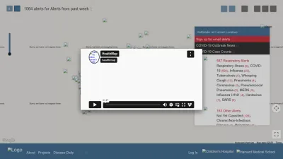
HealthMap is an interactive online platform that lets you explore current outbreaks of infectious diseases around the world. Using real-time data from a variety of sources, you can see maps showing where illnesses like the flu, Ebola, and other contagious diseases are being reported.
You can filter by disease type or location to find information that matters most to you—whether it’s tracking respiratory illnesses, gastrointestinal outbreaks, or even environmental health risks like beach closures. The platform is especially helpful if you want to stay updated on potential health threats in your area or while traveling.
Whether you’re a health professional, traveler, or just someone curious about public health trends, HealthMap makes it easy to visualize and understand the global and local spread of diseases with clear categories and up-to-date information.
 Alternatives to Healthmap.org
Discover websites similar to Healthmap.org based on shared categories, topics, and features.
Alternatives with .org Domain Extension
Find electric vehicle charging stations worldwide with this global, community-driven map and database, updated by EV drivers everywhere.
U.S. Right to Know investigates threats to public health, food, and the environment, sharing research and news to inform and empower the public.
Get wildfire safety tips and tools from CAL FIRE. Learn how to protect your home and community in California with easy guides and preparedness resources.
Explore resources, research, and guidance to improve pedestrian and bicycle safety and promote active transportation in communities across the U.S.
Get practical tips and resources to help protect your home or business from damage caused by natural disasters like floods, hurricanes, and wildfires.
PIRG advocates for consumer rights and public health, offering resources and campaigns to tackle issues like plastic waste and environmental safety.
ICNIRP provides guidelines and information on non-ionizing radiation, helping you understand safe exposure levels for environmental and public health.
Health Care Without Harm (US & Canada) works to reduce health care's environmental impact and promote sustainability in the medical sector.
A global platform focused on transforming food systems through science, innovation, and partnerships for a healthier planet and population.
Explore maps and analysis on the risks of oil and gas development, supporting cleaner energy choices and environmental health for communities.
EWG is a nonprofit site offering research, guides, and tips to help you avoid harmful chemicals and make healthier choices for your family and the planet.
Discover and connect with permaculture projects worldwide using an interactive map and database designed for the global permaculture community.
HabitatMap lets you measure local air quality in real time using portable tools, helping communities track pollution and advocate for healthier environments.
Trinity Metro helps you plan and ride public transit in Fort Worth, offering routes, schedules, ticket info, and real-time updates for local travel.
Download computer-generated mountain panoramas and horizon maps for hiking and climbing across the British Isles, including custom viewpoints.
Global Forest Watch provides real-time data and tools to monitor forests worldwide, helping you track deforestation and land use trends for better protection.
CapMetro helps you plan and pay for public transit in Austin and Central Texas, offering real-time info, trip planning, and fare payment tools.
Metro Transit helps you plan public transit trips, check real-time schedules, view maps, and get updates for buses and trains in the Minneapolis-St. Paul area.
Worldmapper offers unique world maps that resize countries based on global issues, helping you visualize statistics and trends in a new, engaging way.
Sound Transit helps you plan trips, check routes and fares, and find schedules for public transportation in the Seattle and Puget Sound region.
Top Healthmap.org Alternatives (Matching Language)
Find LPG (autogas) stations, installers, and fuel prices across Europe. Plan routes, compare savings, and learn about switching your car to LPG fuel.
MapMyRun helps you track your runs, map new routes, and monitor your fitness progress with easy-to-use tools for runners and walkers.
AGES is Austria's government agency for health and food safety, offering news, alerts, and resources on public health, nutrition, and environmental protection.
Mosquito Alert is a citizen science platform where you can report mosquito sightings to help track and control disease-carrying species. Available in Spanish.
Explore live global maps of wind, weather, ocean, and pollution conditions with interactive animations and real-time data, updated every three hours.
Find reliable info on pesticides, health, and safety. Learn about safe practices, environmental impacts, and how to handle pesticides responsibly.
Helmholtz Munich is a major German research center focused on health and environmental solutions, offering insights, news, and career opportunities in science.
Explore an interactive world map showing light pollution, aurora predictions, observatories, and cloud overlays for stargazing and astronomy planning.
ORISE connects students, graduates, and professionals with STEM internships, research, and resources, supporting science education and workforce development.
Browse daily, global satellite images with NASA Worldview to track weather, wildfires, air quality, and natural events in near real-time.
Shop for bidet toilet seats, air purifiers, and water filters designed for healthier, eco-friendly homes. Discover products to improve your daily comfort and wellness.
Monitor and improve your indoor air quality with Awair. Track air conditions at home, school, or work and get tips for a healthier environment.
Ecolab provides solutions and services for water, hygiene, and infection prevention to help businesses maintain cleaner, safer, and healthier environments.
Elephant Journal offers articles, videos, and a community focused on mindful living, yoga, wellness, spirituality, and eco-friendly lifestyles.
Stay informed with in-depth articles about science, the environment, and health, including climate change, biodiversity, and new scientific discoveries.
Track wildfire smoke and air quality across the US with an interactive map showing PM2.5 pollution to help you prepare and stay safe during wildfire season.
Explore interactive geospatial maps and data for environmental analysis and insights with Earth Engine Apps. Visualize changes and trends easily online.
Garden Collage Magazine explores plants, gardening, wellness, food, travel, and design, sharing inspiring stories and tips for a vibrant, green lifestyle.
Discover tips, recipes, and guides to reduce food waste, save money, and make a positive impact on the planet while enjoying healthy eating habits.
Track flights live on an interactive map and see real-time air traffic from around the world with Flightradar24's easy-to-use flight tracker.
More Healthmap.org Alternatives
Region Syddanmark's official site offers health services, regional updates, and resources on environment, jobs, and social initiatives in Southern Denmark.
French government agency site offering news, reports, and expert advice on food, environmental, and workplace health and safety. Content in French.
Official Dutch site for food, animal, and plant safety. Find regulations, permits, and guidance for businesses and consumers. Available in Dutch and English.
Explore resources and legal insights on climate change, public health, and coastal law, with a focus on Louisiana and disaster preparedness.
greenMe è un magazine italiano che offre notizie e consigli su benessere, alimentazione naturale, ambiente, sostenibilità e lifestyle eco-friendly.
Official German agency site on radiation protection, offering information, safety tips, and research about environmental and health impacts of radiation.
Explore global surface water changes over time with interactive maps and data. Track environmental trends and access downloadable geospatial datasets.
Get schedules, real-time departures, trip planning, and service alerts for Bay Area Rapid Transit (BART) across the San Francisco Bay Area.
Easily customize the look of Google Maps for your apps or websites with this tool. Adjust colors, roads, and labels to match your unique style.
Plan your journey, check bus and tram routes, and buy tickets for public transport in Flanders, Belgium. Site available in Dutch.
Plan your Metro trips, buy SmarTrip cards, view service alerts, and access maps and schedules for Washington, DC's Metrorail and Metrobus system.
Get real-time bus routes, schedules, and service updates for Madrid’s public transportation system. Plan your trips and stay informed easily.
ATM Milano helps you plan your journeys on Milan's public transit, offering routes, schedules, and info for buses, trams, and metro in Italian and English.
PostBus offers schedules, routes, and info for Swiss public bus transport, including updates on electric buses and travel options across the country.
Plan bus journeys, check timetables, and buy tickets for UK bus routes. First Bus helps you travel easily across cities and towns in England, Scotland, and Wales.
Get bus schedules, ticket info, and route updates from Israel's largest public transport company. Plan your trip, find discounts, and contact support easily.
Find useful plugins, controls, and resources to enhance your Leaflet maps. Explore extras that make interactive mapping easier and more powerful.
GPSLogger for Android lets you record and manage your GPS tracks on your phone, view different map presentations, and export location data easily.
Bekijk actuele treinstoringen, vertrektijden en plan je treinreis binnen Nederland of naar België, Duitsland en Frankrijk. Site in het Nederlands.
Find transit routes, schedules, fares, and service updates for The Wave Transit System in Alabama. Plan your trip and stay informed about local transportation.