Water.noaa.gov
National Water Prediction Service - NOAA
Get real-time water data, flood maps, and forecasts across the U.S. with NOAA's National Water Prediction Service. Stay informed about water conditions.
Track real-time water and flood conditions
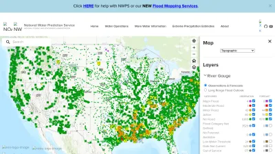
The National Water Prediction Service by NOAA lets you access up-to-date information on water conditions, including river levels, flooding, and forecasts across the United States. Whether you're concerned about local flooding, planning outdoor activities, or just want to stay informed, you can easily view interactive maps and detailed water data for your area.
With user-friendly tools, you can explore flood mapping services and get help understanding current or predicted water events. The site is designed for anyone who needs accurate, timely water information—homeowners, emergency managers, and outdoor enthusiasts alike. It's a reliable resource for staying prepared and making informed decisions about water-related events.
 Alternatives to Water.noaa.gov
Discover websites similar to Water.noaa.gov based on shared categories, topics, and features.
Alternatives with .gov Domain Extension
Track wildfire smoke and air quality across the US with an interactive map showing PM2.5 pollution to help you prepare and stay safe during wildfire season.
Get real-time tide, current, and water level data from NOAA. Access forecasts, maps, and oceanographic info to plan safe trips or monitor coastal conditions.
Browse daily, global satellite images with NASA Worldview to track weather, wildfires, air quality, and natural events in near real-time.
Get official weather forecasts, severe alerts, and safety tips across the U.S. from the National Weather Service. Stay updated on storms, heat, and rainfall.
Get up-to-date, reliable weather info for pilots and aviation professionals worldwide, including forecasts and real-time conditions from the NWS Aviation Weather Center.
Get up-to-date marine weather forecasts and environmental data from NOAA's Marine Modeling and Analysis Branch for safer planning on the water.
NOAA's Environmental Modeling Center shares data, research, and updates on advanced weather prediction systems for scientists and the public.
NOAA OSPO provides real-time satellite data and products for weather forecasting, climate monitoring, and hazard detection in the United States.
Explore severe weather research, forecasts, and safety tips from the NOAA National Severe Storms Laboratory, dedicated to improving storm warnings in the US.
Explore NOAA and NASA's GOES-R series for real-time satellite imagery, weather data, mission updates, and educational resources on geostationary satellites.
Get real-time drought data, forecasts, and planning tools for the United States. Stay informed and prepared with resources from this official government site.
Learn about the U.S. Voluntary Observing Ship Program, access weather logs, and find resources for making and sharing maritime weather observations.
Get real-time tsunami warnings, alerts, and safety info from official U.S. Tsunami Warning Centers. Stay informed to keep yourself and your community safe.
Access near real-time NASA satellite data and imagery for land, atmosphere, and weather monitoring, supporting research, forecasting, and disaster response.
Official U.S. government site for GPS info, offering updates, technical resources, and news about the Global Positioning System and satellite navigation.
Access real-time and historical water, weather, and climate data for California, including reports, maps, and downloadable datasets from state sources.
Explore climate and weather research, Earth system models, and scientific data to better understand environmental changes and predictions.
View archived data, images, and resources from NASA's Tropical Rainfall Measuring Mission, including global precipitation and storm event information.
View real-time maps of Temporary Flight Restrictions (TFRs) issued by the FAA to help pilots and aviation professionals plan safe airspace routes.
Find out when and where to see the International Space Station pass overhead, with easy viewing times and alerts from NASA's Spot The Station website.
Top Water.noaa.gov Alternatives (Matching Language)
Get up-to-date weather forecasts, interactive maps, and severe weather alerts with Weather Underground's Intellicast tools and features.
Get local weather forecasts, long-term outlooks, and precipitation maps for Norway, provided by NRK and the Meteorological Institute. Norwegian language site.
Get detailed 12-day weather forecasts and interactive maps for thousands of locations worldwide. Check live updates on temperature, wind, and weather events.
Get up-to-date weather forecasts, animated maps, radar images, and air quality info for locations worldwide. Available in multiple languages.
Get up-to-date weather forecasts and maps for the UK, Ireland, and worldwide, including marine and travel weather, radar images, and climate data.
Get real-time METAR, TAF, and NOTAM weather reports for airports worldwide, decoded into easy visuals and maps. Supports flight planning and weather checks.
Check detailed weather forecasts, snow reports, and high-res maps for ski conditions and outdoor planning. Get reliable updates to plan your next adventure.
Get surf forecasts, live surf reports, and beach cams for 7,000+ surf spots worldwide. Check wind, waves, and tides before you hit the water.
Check live wind maps, weather forecasts, and radar for any location worldwide. Track conditions for outdoor activities with detailed, interactive weather layers.
Get high-resolution wind and marine forecasts for ocean racing, sailing, and boating with PredictWind’s advanced weather prediction tools.
View live weather maps, track hurricanes and storms, and explore real-time satellite images and forecasts for your location on an interactive world map.
Surfline offers global surf reports, live surf cams, forecasts, and coastal weather updates, helping surfers plan the perfect session anywhere in the world.
Explore live global maps of wind, weather, ocean, and pollution conditions with interactive animations and real-time data, updated every three hours.
Check live wind maps, weather forecasts, and wind speeds worldwide—perfect for sailing, kitesurfing, fishing, and other outdoor activities.
Official Korean government site offering tide tables, sea weather, ocean forecasts, and navigation charts for maritime safety and planning.
Access accurate global weather data and forecasts with Meteosource’s API, including minute-by-minute, hourly, and daily updates for any location worldwide.
Check real-time air quality and pollution levels in Beijing and other cities, view historical data, and access air quality maps and resources.
Find Swiss phone numbers, weather, maps, TV guides, and web search all in one place. search.ch makes it easy to access local info and plan your day.
Track real-time global flight statuses, airport delays, and weather updates to stay informed about departures, arrivals, and travel conditions worldwide.
Check real-time road conditions and traffic updates across Iceland, helping you plan safe and smooth journeys wherever you travel in the country.
More Water.noaa.gov Alternatives
Check live weather radar, forecasts, and satellite images for the Netherlands and Europe. Get up-to-date rain, temperature, and weather alerts in Dutch.
Get real-time weather updates, forecasts, and hazard maps for the Philippines from PAGASA. Access rainfall, temperature, and storm bulletins easily online.
WindAlert helps you track live wind and weather conditions anywhere, with personalized alerts and detailed forecasts for water and air sports enthusiasts.
Get up-to-date weather forecasts, current conditions, and Doppler radar for Ottawa, Ontario on The Weather Channel’s easy-to-use weather portal.
Időkép offers live weather updates, forecasts, and maps for Budapest and Hungary, helping you plan your day with accurate local weather information.
Get free 15-day weather forecasts for France and worldwide, including local, marine, and mountain weather updates. Site available in French.
Get up-to-date weather forecasts, live radar, and climate info for Ireland with Met Éireann, the official Irish meteorological service. Site in English and Irish.
Get real-time weather forecasts, climate info, and detailed reports for any country. Check temperatures, hourly updates, and 10-day outlooks worldwide.
Get detailed weather forecasts for Montreal, including radar, HD satellite images, hourly updates, and alerts for rain, sunshine, and severe conditions.
Get current weather, forecasts, rain radar, and travel weather updates for your location in German on WetterOnline.
Consulta el pronóstico del tiempo en España y el mundo para los próximos 15 días, con mapas, temperaturas y condiciones meteorológicas detalladas.
Check detailed weather forecasts for Spain and cities worldwide, including hourly updates, current conditions, and 14-day predictions. Site in Spanish.
Get up-to-date weather forecasts, warnings, and radar maps for locations across New Zealand with MetService, the country's official meteorological site.
Get accurate local and long-range weather forecasts, radar maps, and severe weather alerts for locations worldwide with Foreca's easy-to-use site.
Get local weather forecasts, typhoon updates, and earthquake alerts for Japan. Features detailed maps, seasonal info, and expert tips. Japanese language site.
Get up-to-date weather forecasts, warnings, and information about earthquakes and avalanches in Iceland from the official meteorological office.
Get real-time weather observations and forecasts for France, with detailed maps, community data, and weather models. Site available in French.
Get current weather updates, 16-day forecasts, rain radar, and weather warnings for Germany and Europe. Available in German with detailed local info.
Get up-to-date weather forecasts for Spain and the world, including temperature, rain, wind, and more in over 200,000 cities. Site in Spanish.
Track recent earthquakes, volcanoes, and natural hazards in New Zealand with interactive maps, data, and real-time updates from GeoNet.